Updates from April, 2015 Toggle Comment Threads | Keyboard Shortcuts

  • Midlothian Valerie 7:56 pm on April 26, 2015 Permalink | Reply  

    Understanding the Value of the Meter stationed in Natalie Creek 

    The ability to display a chart of the ups and downs of Natalie Creek by 149th and Kilpatrick is a wonderful addition to the list of resources available, especially the ability to custom tailor the time frame.

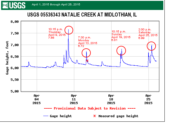
    The following chart is a display of the rise and fall of Natalie Creek from April 1, 2015 through April 26, 2015:

    April-summary-natalie-creek-guage

    The graph shows 4 points on the timeline in which the height of the water rose significantly from its typical 6.00’ish baseline.  The April 25th surge seemed to have a preceding event of an up then down nature.

    The significant drops in water level can be caused by a variety of factors, many currently unknown.


  • Midlothian Valerie 7:19 pm on April 26, 2015 Permalink | Reply  

    April 16, 2015 Rain Ready Steering Committee Meeting 

    Photo courtesy of Floodlothian Midlothian

    Photo courtesy of Floodlothian Midlothian

    The first Rain Ready Steering Committee Meeting was held Wednesday, April 16, 2015 to discuss potential projects, grant opportunities, current progress and more.

    While the members of the Committee passed on electing titles at the meeting, the agenda was primarily worked through by Harriet Festing of CNT and Helen Lekavich of Floodlothian Midlothian.  Other active participants were Village Trustee Karen Kreis, Village Trustee Jerry Gillis, Village Trustee-elect Carl Ivan, Mary Chiz of Floodlothian Midlothian and board member of the Midlothian Public Library and Village Engineer Jeff Koza of Robinson Engineering.

    The meeting was run more similar to a Town Hall meeting, which was far more productive than disruptive.  Members of the audience asked questions and contributed ideas and information.

     
  • Midlothian Valerie 7:05 pm on April 26, 2015 Permalink | Reply  

    The CRS Application Team of Killelea and Cavaney 

    Photo courtesy of Floodlothian Midlothian

    Photo courtesy of Floodlothian Midlothian

    Recently re-elected Village of Midlothian Trustee Donald “Don” Killelea and long time resident and former member of the Midlothian Economic Development Committee, Kathy Cavaney have taken on the long and arduous task of applying for credit with The National Flood Insurance Program’s (NFIP) towards the voluntary Community Rating System (CRS ).

    According to FEMA’s website, “The Community Rating System (CRS) recognizes and encourages community floodplain management activities that exceed the minimum NFIP standards. Depending upon the level of participation, flood insurance premium rates for policyholders can be reduced up to 45%. Besides the benefit of reduced insurance rates, CRS floodplain management activities enhance public safety, reduce damages to property and public infrastructure, avoid economic disruption and losses, reduce human suffering, and protect the environment. Technical assistance on designing and implementing some activities is available at no charge. Participating in the CRS provides an incentive to maintaining and improving a community’s floodplain management program over the years. Implementing some CRS activities can help projects qualify for certain other Federal assistance programs.”

    This checklist of achievements is rough to construct for Midlothian, largely due to pre-existing designs and constructs, but it is not out of the reach of the Village either.  With the team of Killelea and Cavaney logging significant time into the effort, even the short-term benefits will be enhanced with such in-depth awareness into the “technical” side to good watershed management practices.

     
  • Midlothian Valerie 6:38 pm on April 26, 2015 Permalink | Reply  

    Midlothian attends 2015 CSEDC Spring Quarterly Forum 

    On April 24, 2015, Helen Lekavich (Floodlothian Midlothian) and Village of Midlothian Trustee Karen Kreis attended the Spring Quarterly Forum hosted by the Chicago Southland Economic Development Corporation (CSEDC) & the South Suburban Mayors & Managers Association(SSMMA) held in Orland park.

    At the meeting, a not-for-profit organization named High Bridge named the Village of Midlothian as one of the recipients of their objective to install approximately a dozen pilot green infrastructure projects throughout the Millennium Reserve/Calumet River corridor.

    Also, Thomas Vander Woude from SSMMA made comment he was working on providing maps for the Village’s CRS application that recently gained Board approval.

    floodlothian-1

    Photo courtesy of Floodlothian Midlothian

    Helen Lekavich with Village of Midlothian Trustee Karen Kreis, Reggie Greenwood from SSMMA, Mollie Dowling of OAI and Julia Plumb with High Bridge.

     
  • Midlothian Valerie 6:17 pm on April 26, 2015 Permalink | Reply  

    What is The Crater in Oak Forest? 

    Natalie Creek from its start to its finish is a mixture of man-made structures and natural slopes, curves and turns through three communities:  Oak Forest, Midlothian and Robbins.

    Water that collects at/around the George Dunne Golf Course in Oak Forest follows a path that eventually leads to a concrete outlet/pipe behind a shopping mall at 159th and Central in Oak Forest.

    It has been explained by some that The Crater was built somewhere in the 1950’s to take a point of overflow from Natalie Creek and divert it into this decent-sized and relatively deep indentation in the landscape for possible future release back into Natalie Creek at a later time using mechanical pumps.

    From erosion to structural and possession damage and destruction, the role and capacity of The Crater cannot be dismissed from any flood-related conversation, especially any Early Warning System.

    This video shows snippets of video I took within a 30 minute time period.  While there was no dramatic shifts in the water flow while I was at these points, it still is important to be able to view the actual indentation when it is inactive.


  • Midlothian Valerie 5:37 pm on April 26, 2015 Permalink | Reply  

    The Quirky April 13, 2015 Water Level Rise 

    While this text is in hindsight of the content of the video below, I sat in a chair next to the concrete channel on the northeast side of 149th and eventually stopped reading because I wasn’t willing to believe I was actually able to “see” the water rise.

    I had the camera pointed directly at the large pipe taking water from the northwest corner of 149th and Kilpatrick and included a much smaller opening coming from the southeast side of 149th.  There was a pile of stones in the corner and between the eventual coverage of those rocks combined with the smaller opening clearly having little space left before water was going to be halted to some degree.

    Here is a graphic of what the meter read the water levels to be at 15 minute increments.  The timing of the greatest height of the water matches up fairly well with the time I was busy recording that cold morning.

    april-13-2015-kilpatrick-reading

    While reading numbers is important, having video helps create actual match-ups to what a meter is reading and what is going on in actuality.

    I have been asking around since I posted the video if anyone had any ideas as to what might cause such a jump and so far none of the known possible sources add up to the reason and I have also had the ability to watch this same intersection a few times during a patch of rain and I have yet to see the level I saw on April 13.

     
c
Compose new post
j
Next post/Next comment
k
Previous post/Previous comment
r
Reply
e
Edit
o
Show/Hide comments
t
Go to top
l
Go to login
h
Show/Hide help
shift + esc
Cancel